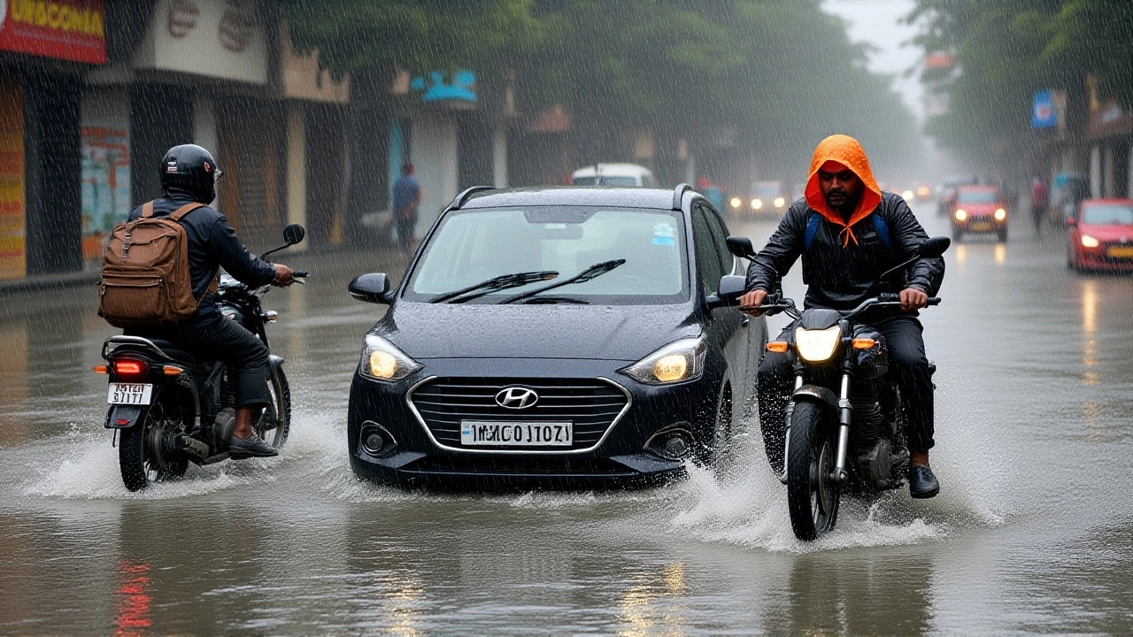
When India Meteorological Department released its latest outlook on October 5, 2025, residents from Kolkata to Delhi braced for a wet spell unlike any seen this season. The agency’s orange‑level alert covers a swath of eastern and central states, warning of heavy to extremely heavy rainfall, thunderstorm activity and gusty winds that could spike to 50 km/h.
What the Forecast Looks Like
Here’s the thing: the IMD expects isolated downpours exceeding 21 cm in West Bengal’s Sub‑Himalayan districts and in the hilly terrain of Sikkim on October 5. Those numbers are more than double the monthly average for this time of year.
Across the plains, the agency predicts heavy to very heavy rain in Delhi on October 6, with thunderstorms peppering the night and wind gusts flirting with 40 km/h. The capital’s temperatures will dip 3 °C below normal, hovering between 31 °C and 33 °C during the day.
Meanwhile, the north‑west sees a different flavor of wet. Jammu and Kashmir, Himachal Pradesh and Uttarakhand are slated for very heavy rain on October 6, accompanied by lightning and gusts up to 50 km/h. The warning stretches from October 5 through October 7, meaning a full three‑day window of potential flooding.
Recent Weather Backdrop
Just before the forecast, a deep depression churned off the east coast, dumping extreme rain in parts of Odisha on October 2. Gopalpur recorded wind gusts of 73 km/h as the system brushed the shoreline. Coastal Andhra Pradesh reported heavy showers, while the hills of Arunachal Pradesh and Meghalaya saw localized deluges.
That episode gave meteorologists a preview of what’s coming. "The system that moved inland yesterday has re‑intensified over the foothills of the Himalayas," said Raman Kumar, spokesperson for the IMD, "and we’re expecting its moisture to be forced upwards, which amplifies rainfall intensity in the sub‑Himalayan belt."
How the Alerts Translate on the Ground
- Orange warning for heavy rain in eastern states (West Bengal, Bihar, Jharkhand) – expect water‑logging in low‑lying urban areas.
- Red warning for very heavy rain in north‑west regions (Jammu & Kashmir, Himachal Pradesh, Uttarakhand) – authorities may halt traffic on vulnerable mountain passes.
- Thunderstorm probability exceeds 70 % in most of the warned zones, with lightning strikes recorded every 10‑15 minutes during peak periods.
- Wind gusts could reach 30‑50 km/h, enough to destabilise temporary structures and uproot trees in rural districts.
Local governments have already activated emergency response teams. In West Bengal, district collectors are positioning sandbags along known flood corridors, while the Delhi Municipal Corporation has pre‑positioned pumps in vulnerable neighbourhoods like Laxmi Nagar and Mayur Vihar.

Expert Insight: What This Means for the Season
Dr. Anjali Singh, climatologist at the Indian Institute of Tropical Meteorology, told us that the pattern is consistent with a stronger-than-usual western disturbance interacting with the lingering monsoon trough. "When those two systems merge, the uplift is dramatic, especially over the sub‑Himalayan belt. It’s not just rain – it’s a cascade of convective storms that can dump a month's worth of rain in a single afternoon," she explained.
She added that October is traditionally a transition month, but this year’s sea‑surface temperatures in the Bay of Bengal are about 0.6 °C above the long‑term average, adding extra moisture to the atmosphere.
Potential Impacts on Daily Life
For commuters, the biggest headache will be traffic snarls. In Delhi, the Yamuna‑crossing flyovers are expected to experience water‑logging, prompting the traffic police to reroute vehicles via the outer ring roads. Farmers in the Gangetic plains are hoping the rains will replenish groundwater, but they also warn of crop damage if the water stays stagnant for too long.
Tourism could take a hit too. The hill stations of Shimla and Manali, both in Himachal Pradesh, have seen a drop in bookings after a red‑level warning was issued. Hotels are offering free cancellations for guests arriving after October 6.

What’s Next? Monitoring and Preparedness
The IMD will release daily updates at 0800 IST, adjusting the colour‑coded warnings as the system evolves. Residents are advised to keep an eye on local news bulletins, mobile alerts, and the department’s official website.
In the longer term, the department is pushing for better drainage infrastructure in urban zones and urging the installation of early‑warning sirens in vulnerable hill villages. "These storms are becoming more intense, and our preparedness plans need to keep pace," Raman Kumar emphasized.
Key Facts
- Alert period: October 5‑7, 2025.
- Highest predicted rainfall: 21 cm+ in Sub‑Himalayan West Bengal and Sikkim.
- Wind gusts: up to 73 km/h recorded in Gopalpur (Oct 2).
- Temperature dip in Delhi: 31‑33 °C (down 3 °C from normal).
- Potential hazards: water‑logging, localized flooding, traffic disruptions, landslides in hilly terrain.
Frequently Asked Questions
How will the heavy rain affect commuters in Delhi?
Roads around the Yamuna and major flyovers are expected to flood on October 6, prompting the traffic police to divert vehicles to the outer ring road. Commuters should allow extra travel time and keep an eye on real‑time traffic apps for updates.
What should residents of Jammu and Kashmir do during the red‑level warning?
Authorities advise staying indoors after dusk, securing loose belongings, and avoiding travel on mountain passes where landslides are possible. Keep emergency kits ready, including flashlights, bottled water, and a charged mobile phone.
Will the rainfall benefit agriculture in the Gangetic plains?
In the short term, the rain will recharge groundwater and soil moisture, which is good for kharif crops. However, prolonged water‑logging could damage seedlings, especially if drainage is inadequate.
What caused the unusually intense weather this week?
Meteorologists point to a deep depression over the Bay of Bengal that merged with a strong western disturbance, creating a high‑moisture environment. Warmer sea‑surface temperatures also amplified the system’s strength.
How reliable are the IMD’s forecasts for the coming days?
The IMD uses satellite data, radar, and ground stations, achieving a forecast accuracy of about 80 % for rainfall intensity in this region. Updates will be posted every morning, reflecting any changes in the system’s path.